March 31, 2012
Long Level, PA to Accomac, PA
section miles: 13 miles total miles: 119
As usual, I'm behind in real-time, and trying to catch up on these entries, so my memory is fading fast. As I post this, we are past York and just two skips from finishing at the AT.
It's been three weeks since our last section hike, and in the meantime spring has washed over the hills of the Susquehanna. The forest floor, previously buried everywhere in a dull brown layer of fall leaves, is now a verdant carpet of new growth. Beds of day lillies have sprouted up, fiddleheads are curling open, and everywhere you look Virginia bluebells and Dutchman's breeches are in bloom. Not that I'm Joe Naturalist when it comes to wildflowers. I'm more like Joe Wikipedia... I look them up when I get home.
Today, as Rene said, was a walk in the park. Literally, in that some of the most beautiful sections wound their way through the Susquehanna Heritage Parks, and figuratively, in that the hills were few and modest as promised by our acquaintences we made on the last section. It was a gray, misty, foggy day, which somehow seemed just right, as if everything about this day was soft and easy. We paid a small price in wet shoes and took our snack breaks on the hoof to keep moving, but it was all fun.
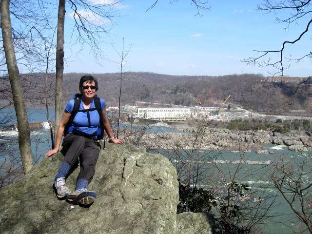
The trail stays close to the river for most of the section, venturing west a bit to wander through the Native Lands county park, and is a pleasant mix of woodlands, grassy fields, and interesting road walking. The trail also brings you to the top of Highpoint Scenic Vista & Recreation Area, which we hear has wonderful views of the Susquehanna, but today it was totally socked in. With a stiff wind and low visibility, it felt a bit like we were really on a "summit." There are some interesting archeological sites in this area, dating back to the Susquehannock Indians, and the Native Lands park provides a nice guided brochure of the trail which points out several as you pass by.
From Highpoint we made our way downhill and eventually arrived at downtown Wrightsville, stopping in at a local Italian place to get out of the weather and scarf some lunch. First time I've ever hiked with a pizza box full of left-overs tucked in my pack. Dropped in at the historic John Wright foundry to have a look at their store, which is - as you might guess - now a tourist shop for women's shoes, clothes, jewelry, and assorted jams and pretzel dips. We were expecting... I dunno, iron, I guess. They had some hooks and latches tucked away in a far corner, as if they didn't want anybody to actually buy that stuff, but further exploration led me upstairs to an outlet floor of Taiwanese seconds, pallets stacked high with various iron "things"... like metal cows with broken horns and nifty Victorian latches with no latch. The floor was creepy vacant and depressingly junky, so I quickly made my way back down to the pretzel dips and grazed patiently while Rene boosted the local economy.
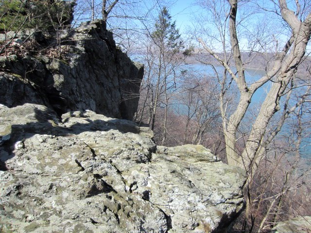
The last bit of trail north of Wrightsville led us down by the river through some private settlements, ranging from simple camps to artsy homes, before arriving at the Accomac Inn where our car awaited. Throughout the day we had been passing over hills of slate bedrock, which presumably accounted for their relatively gentle topography, but here we skirted below a substantial ridge of quartzite looming above the houses. In places these outcrops formed impressive cliffs that would be a rock-climber's paradise if not situated on private land. I half-expected the trail to head straight up at some point, but thankfully, no.
That's it for our day hikes. We're far enough from home now that we'll finish the last four sections with a couple of overnight trips, so we don't spend half the day just shuttling cars back and forth. The AT seems almost in sight at this point!
Sunday, April 8, 2012
Sunday, March 25, 2012
Section 9: Otter Creek to Long Level
March 11, 2012
Otter Creek Campground, PA to Long Level, PA
section miles: 13 total miles: 106
Let's not mince words here - this section was brutal. Thirteen miles, at least twenty of which were straight up 400' cliffs. Or so it seemed. We nicknamed it "The Dragon's Spine" for the endless knee-jarring ascents and descents along jumbled, rocky ridgelines not suitable for mature audiences. There were plenty of opportunities for the trail to skirt harmlessly around these outcrops, so that one could admire them from a distance as God intended, but clearly the Mason-Dixon folks had more interesting challenges in mind. Either that or they employeed a troup of overly-rambunctious boy scouts to blaze this section. Took us over eight hours, which gives you a pretty good idea of the plodding pace, and a quick glance at a topo map showing the contour lines condensed to a black smudge along the river gives you a pretty good idea of the difficulty. We've climbed entire mountains that took less effort - a fact I never failed to wheeze out whenever we met fellow hikers crawling past us in the other direction.
The day started out, however, relatively tame. A beautiful sunrise greeted us upon arrival at our drop-off, and the first few miles heading north from Otter Creek Campground were a jaunty stroll. We felt strong, and complimented ourselves on how easily we tackled the first elevation gains as we passed through rather non-descript woodlands. Scenic overlooks provided some fabulous views of the river bathed in early morning light. We chatted about our good progress and how we should make it to Wrightsville by early afternoon, with plenty of time left in the day to play tourist. So much for that idea.
Beyond the three mile mark, or so, you begin to pick up lingo in the trail guide that will dog you the rest of the day. "Climb steeply by switch back... Climb steeply on stone steps... Climb the cliff and and follow the crest of the ridge... Reach high point and begin steep descent... Pass a small, overgrown graveyard with the remains of many hikers..." Okay, kidding about the remains, but I wouldn't have been surprised. I would like to recount some interesting stories, but other than seeing a couple of eagles and a flock of trumpeter swans during a rest break, I pretty much stared at my feet all day. We stopped to commiserate with another pair of hikers about midway through and learned that people actually run this trail as part of an ultra-marathon. I can't imagine.
Near the end of the day, as we summitted our last dragon spine, we met one more hiking couple. They confirmed out that we had, in fact, seen the worst of it, and the trail beyond this point would soon return to gentler terrain. From this vantage point - an imposing cliff overlooking the river towards the north - one can see that the topography changes markedly. The river broadens out considerably, and the flanking hills look more welcoming. There must be some interesting geology underlying this change, as you get the impression that whatever compression buckled the steep ridges to the south came to a rather abrubt end at this juncture, or perhaps more accurately, folded down into a basin. Here the west bank is known, appropriately, as "Long Level", and roads follow along the river on both sides to Wrightsville. Across the river this same abrubt elevation change is marked by Turkey Hill, famous as the home of Turkey Hill ice cream. So close, and yet so far.
With all that said and done, we did enjoy this section, and I "complain" about it in good spirit. Spectacular views and the satisfaction of meeting a difficult and novel challenge (for us) made it well worthwhile. Not that we intend to do it again anytime soon, mind you. For anyone contemplating this section hike, assuming you don't regard marathons as simply a pleasant jog, we suggest splitting it into more reasonable chunks, allowing yourself plenty of time to rest and enjoy the scenery.
We're now over 100 miles from our front door and two-thirds of the way to the AT.
Postscript
I happened upon a video on youtube of boy scouts backpacking through this section. Gives you a pretty good idea of the experience. Mason-Dixon Trail video
Saturday, March 24, 2012
Section 8: Muddy Creek to Otter Creek
March 8, 2012
Muddy Creek Access, PA to Otter Creek Campground, PA
section miles: 12 total miles: 93
It's difficult to imagine a more varied hike than the trail from Muddy Creek to Otter Creek. This section has it all - exploring several remnants of the Susquehanna and Tidewater Canal lock system, clambering around the islands of the Susquehanna, steep ascents to the ridge overlooking long stretches of the river, secluded creeks that tumble through sun-dappled woods, even more picturesque farmlands, and surprisingly rugged, rocky outcrops. I don't know how many times we stopped to admire a tranquil pool of water, remarking that it looked like a Japanese garden, only to find an even more impressive garden further on. In short, this is a very interesting and beautiful section of the trail.
From the Muddy Creek access point you head along the banks of the Susquehanna to the Lock15 interpretive park, where a nicely preserved canal lock is easily accessible and well documented. It's worth spending a little time here before heading up the river and onto Peavine island. The rocks on this island form impressive mounds of river-smoothed schist liberally studded with garnets, and required a bit of scrambling to navigate. Hiking across the island was a bit tricky - trail blazes were difficult to find, and flood debris in the lower elevations led to a bit of off-trail bushwacking, but we eventually found our way off at approximately the right point and rejoined the well-marked trail on the bank.
Once on shore, you pass a few more canal locks before turning west up the very scenic Mill Creek. Somewhere on this foray we were mindlessly hiking through a quiet wooded section when a sharp woof-bark-snarl brought us immediately into the present. We both instantly lept aside, hiking poles raised for battle, only to discover a big, fat, very pissed-off racoon glaring at us from behind a pine tree. I had no idea they could do grizzly-bear imitations. It was a good ten minutes before our heart rates returned to normal.
Beyond Mill Creek, the trail heads steeply uphill to some very scenic overlooks of the river and Holtwood dam. The trail drops down again to follow the river bank before heading up Oakland Run, another very scenic tributary, and from there you follow a long uphill slog through state game lands, emerging into wide-open farmlands. A few miles of scenic road walking brings you back to the woods, where you descend (steeply!) down Furnace Run and Sawmill Run to the Otter Creek campground on the banks of the Susquehanna. In a completely senior moment, we had no clue whether our car was parked upstream or downstream from where we popped out. We wandered up and down the road a bit, trying to recognize a landmark, before deciding to split up - Rene hiked up-river, I hiked down-river, and I eventually stumbled on the car. Lesson learned.
Subscribe to:
Posts (Atom)