Elkton, MD to Newark, DE
section miles: 9.5 total miles: 16.0

The starting point for today was Meadow Park in Elkton, MD, heading back toward Newark, DE. This park is situated on the floodplain of Big Elk Creek, and the first mile or so of the hike followed the south bank upstream. Flood deposits were everywhere, from piles of flotsam to substantial sand bars and downed trees. It was difficult to follow the trail, and we bush-whacked for a while before eventually stumbling back on the blue-blazed path. Rene spotted a fox on the opposite bank standing up on its hind legs to get a better look at us, and after a little observation we noticed that there were actually two foxes having a little morning wrastle. A few steps further on we jumped a great blue heron wading in the creek. Signs of an ambitious beaver were everywhere - he seemed to fancy the biggest trees he could get his teeth on, but apparently was easily distracted and never finished the job.

We soon passed by a pond with a skim of ice, and a bit further on came to a large field of rectangular, earthen water reservoirs as the trail wandered further from the creek. Most were empty. Perhaps the water supply for the city of Elkton? (Edit: this is apparently a fish hatchery.) Past another frozen pond, then a scramble up a surprisingly steep, tall bank and we were finally above the floodplain.

After a relatively short jaunt through the woods the trail dumped us out into our first subdivision. This was challenging, to say the least. The trail markers are painted on the curbs, when you can find them... and that’s the challenge. It’s particularly tricky when the trail crosses a road. After spilling out of the subdivision, we had to wander up and down a very busy road looking for any sign of the trail picking up on the other side. At one point we found a blue marker in the side yard of a beat-up looking auto repair shop - either that, or some guy who collected lots of broken, derelict cars - with a friendly “No Trespassing” sign posted right above the blaze. And it was not terribly obvious where the trail went from there. We steeled our nerves, preparing to be yelled at, and strolled quickly through the yard, past a couple rusting heaps and a “Beware of Dog” sign. A couple very well-hidden, questionably faded blue blazes further on in the bushes gave us hope we were on the right path, but we wondered if this was an old path that had been re-routed. Behind the auto shop we came to some town houses, and again had to walk through somebody’s side yard, hoping we were still on the right path. At that point we had no idea where the trail went. We walked up the road in front of the town houses, but saw nothing, so decided to forge on across the street through another field marked “No Trespassing - City of Elkton”. As we neared a gas line we finally found some blazes, but again, they looked suspiciously faded.

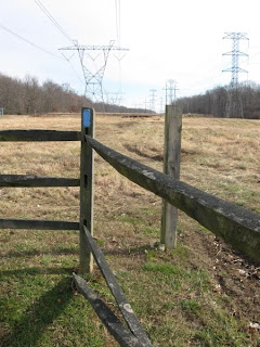
The questionable path eventually dumped us out into a high-voltage power line easement, and bright blue slashes assured us that we were on the official trail again. The trail followed the power lines for several miles. Somewhere near the beginning of that stretch we crossed into Delaware, and towards the end we had a difficult time trying to find the trail at the point where it leaves the power line easement. We spent many minutes wandering around separately in the woods looking for any sign of a trail at all, eventually stumbling upon the right path through a pleasant (but very wet) woodland and into our second subdivision, then emerging onto Old Baltimore Pike across the street from Iron Hill Park.

The Iron Hill walk was wonderful. Excellent trail and a beautiful small park. By strikingly random concidence, we met a group of middle-aged hikers heading south and learned that they too were intending to hike the entire Mason Dixon Trail. They had started in Pennsylvania and were working on their third segment.
Crossing over I-95 from Iron Hill, it was a short jaunt through another small neighborhood, then down the hill to Rittenhouse Park to finish up the segment.
Trekkie Notes
The trail east of Elkton can be very difficult to follow. We promptly decided that we need to buy trail maps - depending on well marked blazes is clearly hit or miss. Low-lying areas adjacent to Big Elk Creek have substantial flood deposits to negotiate, and I think we were off the trail much of the time. The neighborhoods you pass through seem safe enough, but there are a few areas where we kept our eyes peeled for potentially aggressive dogs and property owners. Hiking along the power lines is a tad unnerving, with a constant electric buzz in the background, and a nagging sense that utility company security might show up at any moment to investigate. Four-wheel ATVs tracks are coincident with the trail in many places. In short, a mixed section with a few nice stretches and a few dodgy stretches.
No comments:
Post a Comment